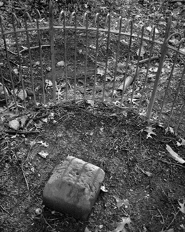
Silver Spring: north corner boundary stone
- Matthew P G

- Jun 23, 2022
- 3 min read
Updated: Mar 17, 2023

North Corner Boundary Stone, District of Columbia. April 2013
Mega-walks
Life was in a huge pause. I was in the process of looking for a job overseas because I desperately needed income. I had irons in the fire, but nothing concrete. Luckily, I had a calm place to crash with PM and DV in Washington while I made a new game plan. During that time, to clear my mind I took mega-walks all over the District. That in itself was novel to me because I was able to walk through places that, during my Georgetown years, would have been strictly off-limits because they were "bad neighborhoods". DC, for better or worse, had gentrified a LOT.
I was walking the District in sections trying to have a theme or a destination on some days just to give myself purpose and focus (which deflected thoughts about my collapsed life). I got it in my mind to find the northern tip of the District. It appeared on maps, but none too clearly, so I set forth from Brookland Metro Station to find the "North Corner Boundary Stone". I alighted at Friendship Heights Station and walked up Western Avenue toward Rock Creek. I loved that stretch of road because people on one side lived in the District and the other in Bethesda or Chevy Chase, Maryland. I wondered if there was much of a sense of community. To most people it appeared to be one wide avenue passing through a neighborhood with similar houses on either side of the street rather than a state boundary. Did that border matter to the residents other than tax and election times?
Western Avenue ended abruptly at Rock Creek Park and there was an unmarked trail that continued steeply down to the creek. I knew this from having walked the opposite direction a few days before. I crossed Beach Drive and then Rock Creek itself over Boundary Bridge. A feeder trail for the park connected "The Valley Trail" with Grubb Road just on the Maryland side. That trail roughly followed the District line. At Grubb Road the trail ended and I had to take a short detour through some bland apartment complexes to get to East-West Highway.
East-West Highway was just that, a highway and a busy one at that. It made for very unpleasant walking after lovely Western Avenue and Rock Creek Park, but I was getting closer. The sidewalk did NOT cooperate as it shifted from one side of the road to the other which meant crossing East West Highway (not easy) a few times. Finally, at the crest of a small hill, the map indicated I was "there" - but where? Not obvious and down a small bank from the highway was a little wrought-iron enclosure and inside that, a weathered stone (as pictured above). Success! I was happy to have found it, but admit to disappointment at finding it on an embankment just under the East-West Highway.
Working under the supervision of three commissioners that President George Washington had appointed in 1790 in accordance with the federal Residence Act, a surveying team that Major Andrew Ellicott led placed these markers in 1791 and 1792. Among Ellicott's assistants were his brothers Joseph and Benjamin Ellicott, Isaac Roberdeau, George Fenwick, Isaac Briggs and an African American astronomer, Benjamin Banneker. Today, 36 of the original marker stones survive as the oldest federally placed monuments in the United States.
(Wikipedia)
Since finding that boundary marker I have stumbled across others (original and remade) on long walks in DC. Now knowing what they look like and how to keep an eye out, they seemed to be hidden in plain sight all along the edges of the District. Since they are the oldest "federally placed monuments" in the US, they are noteworthy even if not particularly exciting.
On that day of locating the North Corner of DC, I continued along East-West Highway the short distance to Silver Spring Metro Station and headed back to Brookland. Mission accomplished - I had seen the boundary stone and managed to forget my life for a few hours. All in all, it was a good adventure.


Comments